Hydrogeochemical Evaluation of Groundwater in a Micro-Watershed of Ranganadi River Basin in Arunachal Himalaya
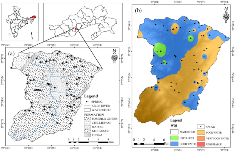
Water is critical for maintaining ecological and environmental equilibrium, as well as meeting drinking, agricultural, and industrial needs. This study focuses on mapping the springs and assessing their water quality for drinking as well as agricultural use in a micro-watershed (Kille watershed) in the Ranganadi river basin in Arunachal Pradesh, Northeast India. A total of 64 springs studied for their Water Quality Index (WQI)provided a comprehensive view of groundwater quality, classifying samples across a range from “excellent” to “very poor,”. Among the 64 springs, 30 fall under the “good”category while 28 are categorized as “poor.”Spatial distribution maps of WQI indicated significant variability in groundwater quality, identifying regions with poor WQI that require immediate attention and further investigation.
The pH levels in the study area are moderately acidic to basic, with 79.69% of the samples within the permissible range. The slightly acidic nature of the water, as evidenced by the presence of free hydrogen ions or the dissolution of Ca2+ and Na+ from the surrounding rocks (aquifer), along with organic matter decay. The dominant geochemical composition of water includes Ca–Cl, Na–Cl, mixed Ca–Mg–Cl, and Mg–HCO3 types, constituting 39.06, 31.25, 26.56, and 3.12% of the samples, respectively. Hydrochemical facies highlighted the dominance of alkaline elements over alkali (Ca + Mg > Na + K) and strong acidic anions over weak acidic anions (Cl + SO4 > HCO3). The intermixing characteristics of the water type were majorly found as Ca–Mg–Cl–SO4, and Na–K–Cl SO4 type. Irrigation feasibility was evaluated using parameters such as SAR, RSC, MH, %Na, PI, and KR. The evaluation of groundwater suitability for irrigation highlighted that SAR analysis categorized all samples as excellent. Similarly, findings from the Wilcox plot and USSL diagram categorized all samples as excellent for irrigation, with low to moderate salinity and low sodium levels, respectively. The RSC, KR, and PI results suggest that the water in the study area is suitable for irrigation purposes. However, MH indicated raised concerns as a majority of the samples are within the unsuitable category, suggesting leaching of Mg2+ from rocks or potential reverse/inverse ion exchange.
The above findings suggest that a significant portion of the groundwater is suitable for sustainable agricultural practices. This comprehensive study deepened our understanding of groundwater quality and offered valuable insights for water resource management decisions. The findings underscored the need for targeted interventions of water tanks and distribution, especially in the North-Western area of the Kille watershed, to improve water quality. Additionally, areas with poor water quality warrant further research into sub-surface conditions, population distribution, and groundwater monitoring to ensure the provision of safe drinking water. The study advocates for effective groundwater management and sustainable agricultural practices to enhance the well-being of local communities and the environment.