Rejuvenation of the Kosi River of kumaun Himalaya through field intervention and People participation
Spring-fed Kosi River is flowing through Almora and Nainital districts of Uttarakhand. This river is the principal tributary of River Rāmgangā (West) System (Figure 1). The Kosi River originates from its North most point at Pinath (NW of Kausani, district Almora), which flows down towards the discharge point at Kosi Barrage (Rāmnagar, district Nainital). Geographically, the catchment has its spatial extension between 290 22’ 41.60” to 290 52’ 20.81” N latitudes and 790 02’ 38.21” to 790 51’ 15.08” E longitudes, which covers about 1868.64 km2 area. The absolute relief of the catchment ranges between 349 m and 2758 m from the mean sea level. Undulating topography, micro climatic conditions etc. pose some difficulty in the wise distribution of natural water resources. In this zone, rain fall occurs in spring, monsoon, and winter seasons. The ultimate store house of water is mountain groundwater which outflows as spring water (in the form of locally known as ‘Naula’ and ‘Dhara’) at up-slopes, middle-slopes, and down-slopes. At some gentle slopes, plane areas and where required, hand pumps and tube wells were used to excavate water. Kosi Basin is divided into four sub-watersheds namely Upper Kosi, Suyal, Ramgad and Kuchgad sub-watershed ranging in area between 400 to 540 km2.
Kosi River is the lifeline of Almora City and villages, as it serves all types of water requirements for lakhs of people who live in the command area of the river. It is mainly a rain-fed river, and for the last few years the volume of water in the river has been decreasing and has reached a critical condition. The mountain aquifers that have been serving as a source of water in the river have now become aquitards. The number of springs (‘naula' or ‘srot' in the region), that supply the water in the river have reduced to almost less than half in past few decades. Various efforts have been taken by the local government for recharging the springs for revival of Kosi rivers, including preparation of water conservation structure (trenches, pit holes, check dams, ponds etc.), plantation etc. For understanding the impact of such efforts and to understand the right way of water conservation approaches, this project was developed. As pilot site Deolikhan (Garhwali catchment) and Simtola recharge zones of Hawalbag block of Almora district was taken (Figure 1).
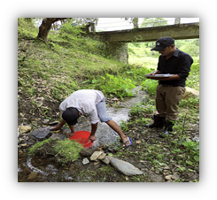
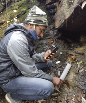
The mainstream of the Garhwali catchment is perennial in nature, whereas the Simtola catchment has seasonal flow in the mainstream. In both the catchment areas, there is no groundwater exploitation by constructing bore wells or dug wells. Water quality and discharge (Figure 2) was continuously estimated for the springs and streams flowing through these pilot sites. Most of the parameters were found in the permissible limit as per BIS 2012 drinking water norms, except iron and alkalinity. The iron content might be attributed due to the presence of Almandine Garnet which are found imbedded in Garnetiferous Mica Schist.The direct impact of rainfall on discharge rate was observed. Through infiltration rate assessment it was observed that the soil surface is crusted in the study site, that’s why it is prone to erosion. Through geophysical survey conducted in the pilot sites it was observed that the lateral distribution of resistivities indicates that the groundwater prospect in the larger part of Gadhwali catchment is better than the Simtola catchment area due to the presence of deeper fractures and joints are intense.Based on resistivity variations, several subsurface lithological geometries i.e., soil, weathered and fractured units and their hydrological properties have been recognized and analyzed to understand the condition of groundwater in schist aquifer system of both catchment areas.
Two main approaches mechanical & biological treatment is being implemented, in convergence with NMHS-SGP Kosi River rejuvenation Project. Works for rejuvenation of Kosi River are being undertaken under two components, i.e. Biological & Mechanical measures. Biological measures involve planting tree saplings and grass plantation to hold the soil cover and increase infiltration of rainwater. Check Walls and wired fencing are being done to protect the saplings from animals and forest fires. Apart from this, mechanical measures involve digging of Infiltration Holes, Infiltration Trenches, Ponds to retain the runoff during rainfall over mountain slopes. Concrete Check dams and Bio-check dams are being constructed at specific sites such as in second / third order streams flowing down the steep gradient.Under the project several types of awareness programmes have been conducted, such as swatchta abhiyan, plantation, and discussions with communities, in many locations within the Kosi River’s watershed.awareness programmes have been held at several locations along the Kosi River, including Kayala, Gadhwali, Badhgal Bhatt, Badhgal Rautela, Bhasoli, Siyona, and Ghanaeli villages
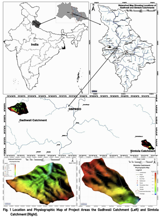
Figure 1. Location and physiographic map of project areas (Garhwali catchment and Simtola catchment)